A privileged site, accessibility, organization of the built
- A privileged site
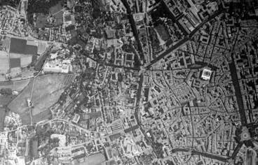
The programme site enjoys a privileged geographical location in the urban landscape of Aix.
It is a plot of 8 hectares, located in the Saint-Eutrope district, north of the city, at the foot of the hill of Entremont. It corresponds to an irregular diamond-shaped mound in its northwest part. It is oriented north-west, south-east in the direction of the length.
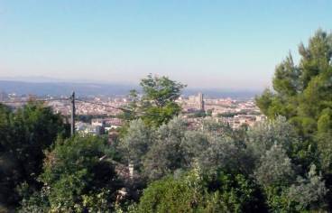
Its plateau rises to 266 meters and offers a quasi-aerial view of the city to the south, and a exceptional panorama lost in the distance on the chains of Sainte-Victoire, the Etoile and the Montaiguet.
The north and north-east thirds show fairly low slopes. In its first third, to the south-east, two slopes limit it; one, to the south, in regular slope with a slope of 7 meters, the other, to the west, shows a steep slope of 20 meters softened by terraces.
- Accessibility, service
The City of Beisson is located in the immediate vicinity of two major roads consisting of the old Alpine road, which feeds to the north, one of the main accesses of the city, and the ring road, which serves the accesses of theThe city and the network of the main traffic routes of the whole conurbation converges.
Thus three accesses are possible:
- by the north, from the old road of the Alps from where one reaches, at its junction with the avenue Jules Isaac, the avenue des Peupliers which leads to the avenue Poincaré,
- by the south-east, from the ring road, Place Bellegarde, using Avenue Jules Isaac and then Avenue des Peupliers to Avenue Poincaré,
- by the south-west, from the ring road, up Avenue Pasteur and then Avenue Paul Cézanne, on which Avenue Poincaré is located.
This service is ideal since the two routes, south-east/south-west, meet in a loop.
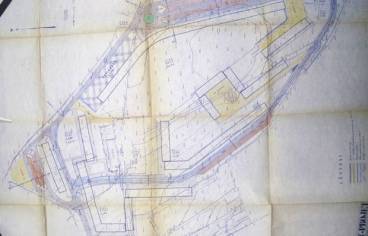
The parcel is delimited by:
- Raymond Poincaré Avenue to the north and east.
- to the west, Avenue Paul Cézanne and Rue Vincent Auriol.
- to the south, rue Vincent Auriol.
The buildings are served by two penetrations:
- Vincent Auriol Street grafted at its northern and southern ends on Raymond Poincaré Avenue irrigates the program in its western part.
- René Coty Street grafted to the northeast on Raymond Poincaré Avenue irrigates the program in its eastern part.
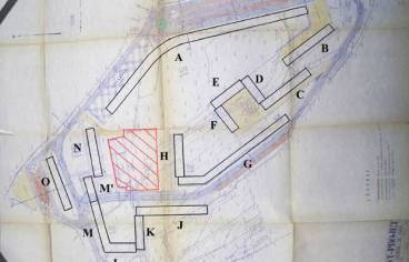
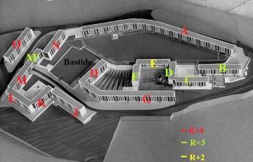
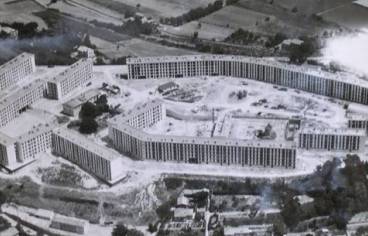
The program includes 15 bar buildings each named by a letter from A to O (no I), and a shopping mall on the ground floor of Building E.
Les Departmental housing are gathered in buildings A – B – C – D – E – F – G, the Municipal Office administers buildings H – J – K – L – M – M – N – 0.
The organisation of the building takes into account four factors: the particular shape of the land, the rugged topography, the essential views to be preserved and an enclave constituting an extremely restrictive servitude (area shaded in red, plan), imposed by the seller who keeps, in the north of the land, in the widest part and in the central position, a hectare of garden around his bastide.
Faced with these constraints, the architect was able to make the most of the constructive potential of the terrain and the surrounding panorama.

Les volumes bâtis sont repartis en bordure de parcelle. Le plan présente une composition fermée dont la disposition des bâtiments ne répond à aucune exigence d’orthogonalité ou d’axialité.
Les immeubles, libérés des contraintes du parcellaire et de l’alignement sur rue, sont disposés selon des principes combinatoires dynamiques aux formes variées : le plan rectangulaire décliné de façon simple (Bâtiments B, N et O) ou le plan combiné, en retour d’équerre (Bâtiments C, D, E, F et J, K, L, M) et le plan incurvé (Bâtiments A et G).
All buildings show a homogeneity factor by respecting a reasonable and almost identical construction scale throughout the program: the buildings positioned at the edge of the plot do not exceed four floors (two or three for those located inside the plot in its southern tip); a homogeneity that harmonizes with the urban scale, classic, of the city.
Les bar buildings are divided into small units that are articulated to each other. Their joints follow the irregular shape of the plot.
The declivity has allowed a step-by-step planning logic to offer unobstructed views of as many apartments as possible to enjoy the surrounding landscape.
The layout of the buildings favours an east-west orientation to offer them the best sunshine.
Traffic and parking areas are rejected from outside the program to favour the interior development of highly differentiated pedestrian collective spaces.
Four car parks are planned in the east, facing Building A, in the north, behind Building O, in the west, facing Buildings L, and in the west facing Building G. Their area is 2,900 m² for about 200 parking spaces.
It should be borne in mind that the parking standards laid down at the time in the Industrial sector are a car for four homes!
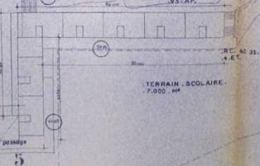
Part of the land is reserved for the construction of a school.
The architect Olmeta proposes in this program a composition of modern volumes that prints in the urban fabric of the district a new and innovative dynamic that is expressed by the introduction of a new typology in the architectural vocabulary of the district, that of thebuilding-bar, which it declines here in two forms yet diametrically opposed: the curve and the line. Segmentation of the other is opposed to the fluidity of one.
While adhering to the major urban and architectural principles advocated by the Modern Movement[1], Olmeta makes the choice of a closed composition that may appear as anachronistic in relation to the functionalism of the open order advocated by the Charter of Athens in terms of urban disposition.
But this plan shows above all the will to create not a large group of isolated and repetitive buildings, set in the middle of a vast green area without limits, fences, thresholds, but on the contrary, to create here a new limited locality, The structure of this complex is more like a reasonable and autonomous residential complex, designed in relation to the scale and spaces of the traditional city; principles of urban layout that reflect the image of the village or citadel.
The major road works carried out at the time to facilitate access to and service to this city highlight the municipal will to register this program not as an isolated urban enclaveeven, but as the generator of a new urbanity.
The neighbourhood retains its residential vocation but now incorporates the contrasts resulting from the juxtaposition of different forms of sociability, ranging from small individual property to social housing in large collective.
Its modern, monumental writing, strongly present in the urban panorama of the district, disrupts in a single stroke the usual centuries. It is in rupture both in form and scale with the surrounding urban fabric of the time which still displays a profoundly rural character.
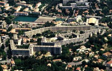
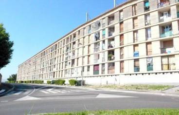
It becomes the strong urban signal of a new modernity that is apprehended thanks to a bold bias that the architect imposes by his choice to position a front built continuously over 350 meters, which marks the eastern horizon of the plateau, facing the Sainte-Victoire mountain, and inscribes with virtuosity and insolence, the City Beisson in its urban setting.
The inflected shape of the building, probably suggested by the natural curvature of the ground, allows the innovative identity of the program to be established from the outside. Its vast "Coliseum" frame visually expresses the statistical density of housing needs that suddenly appeared at that time. From the inside, it is a real stage wall, the cavea an ancient theatre, where the daily spectacle of life unfolds in this city.
The famous "banana"of the City Beisson has become a key landscape that illustrates the introduction of a new aesthetic, a new urban attitude and a new modernity in the life of this district.
The privileged geographical location of the city and its connection with the city allow it to be part of the continuity and not in rupture with the traditional city.
By dealing with the natural configuration of the terrain, Olmeta gives its program a singular form and thus clearly identifiable.
_______________________
[1] At the origin of the conception of the architectural and urban form of the great ensembles are the theories of the Modern Movement – rationality, functionalism, hygienism – a movement born in the years 1920-1930 including the architectural and urban doctrine, formulated in 1933 in the Charter of Athens, is disseminated through the CIAM (International Congress of Modern Architects). The theories of the Modern Movement are influenced by other movements such as Cubism, Bauhaus, De Stijl and Italian Futurism. The emblematic figures of this movement are Le Corbusier for France, Mies Van der Rohe and Walter Gropius for Germany.
Partager la page